The NYC Subway Map Manhattan is a geographically-modified representation of the subway lines and stations within the borough of Manhattan, New York City. It is designed to be informative and user-friendly, helping passengers navigate the extensive subway system.
Related Post –
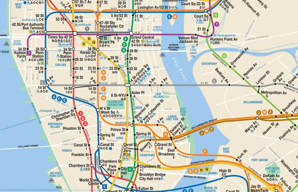
NYC Subway Map Manhattan
Here’s a breakdown of its key components:
Lines: The map displays all subway lines running through Manhattan, categorized by color and symbol. Local and express services are differentiated, with local stations marked by black circles and express stations by squares. Additionally, part-time line extensions are indicated with a dashed line.
Stations: Each station is represented by a circle, with its name clearly labeled. The stations with free transfers to other subway lines are highlighted with a connecting line and the specific lines involved. Stations offering free out-of-system transfers (e.g., to the PATH train) are further distinguished.
Geography: The map intentionally modifies the geographical layout of Manhattan for clarity. Streets might be shifted or exaggerated to accommodate the intricate network of lines. This prioritizes information presentation over precise geographical representation.
How to use the Manhattan NYC Subway Map
The NYC Subway Map Manhattan is your key to navigating the city’s vast underground system. Follow these steps to make the most of it:
1. Download a Map:
Before venturing underground, download the official subway map onto your phone. The MTA website offers printable and downloadable versions. Alternatively, consider using apps like Citymapper or Google Maps, which offer real-time information and integrate with the subway map.
2. Plan your Trip:
Identify your starting and ending locations. Use the map legend to understand the different lines and symbols. Look for stations closest to your starting and ending points.
3. Choose the Right Line:
Determine the subway line that best connects your points. Consider factors like express vs. local service, transfer options, and travel time. The map shows the number of stops between stations, helping you gauge your travel time.
4. Identify Stations and Transfers:
Locate your desired stations on the map. Pay attention to stations with transfer icons, indicating connections to other lines. This helps you plan your journey efficiently and avoid unnecessary backtracking.
5. Navigate the Stations:
Follow signs within the station to find the correct platform and direction. Use the map’s direction indicators to ensure you’re headed the right way.
6. Fare Payment:
Purchase a MetroCard or use an OMNY card to pay for your ride. Swipe your card at the turnstile before entering the platform. You can also use contactless payment options like Apple Pay and Google Pay through OMNY.
7. Board the Train:
Wait for your designated train on the platform. Look for the train’s number and destination to ensure you board the correct one.
8. Stay Informed:
Announcements within the station and on trains provide real-time updates on delays, service changes, and upcoming stops. Monitor the interactive displays on platforms for arrival times and train information.
Benefits of Using the New York Manhattan Subway Map
- Efficient Navigation: Quickly identify the best route for your trip, minimizing travel time and confusion.
- Cost-Effective: Plan your journey to optimize transfers and avoid unnecessary fares.
- Accessibility: Access key information about accessible stations and transfer options for those with specific needs.
- Time Management: Estimate travel times between stations and plan your schedule accordingly.
- Exploration: Discover new areas and attractions accessible through the subway system.